Overshooting tops database for 20 June 2013 and 29 July 2013 (based on Meteosat-8, 2.5-minute rapid scan data)

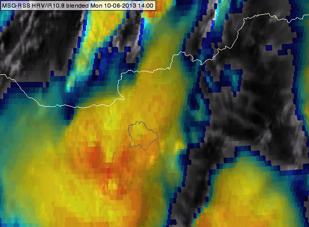
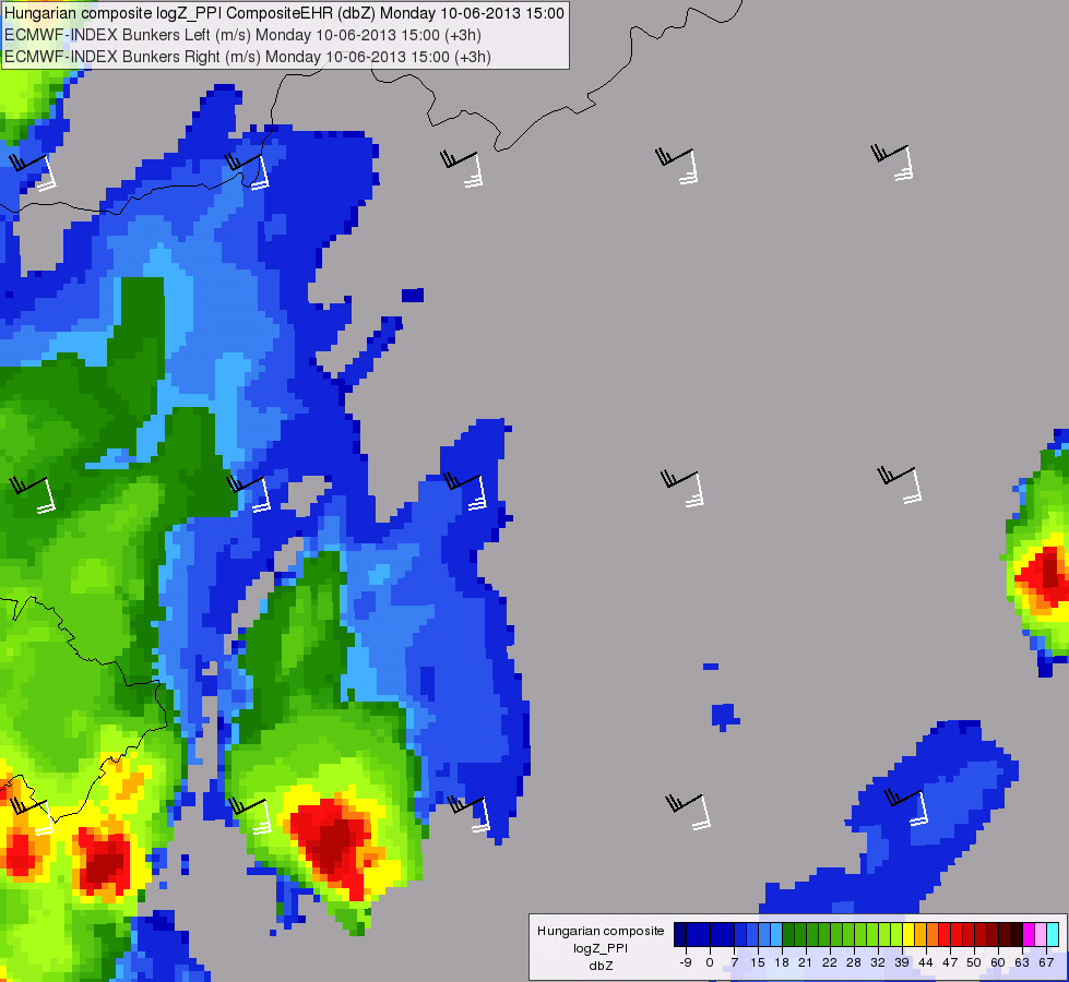
Martin Setvák and Michaela Radová (Czech Hydrometeorological Institute, Praha, Czech Republic) have compiled a database of subjectively detected overshooting tops, based on data from the MSG-1 (Meteosat-8) 2.5-minute rapid scan experiments. As the subjective detection of overshooting tops was based on HRV data, it can be used either for validation of various automated OT detection methods (VIS or IR based), for development and testing of new OT detection algorithms, or for any research purposes.

The database contains series of images (HRV, IR10.8-BT, sandwich of HRV and IR10.8 bands, sandwich of HRV and the Storm RGB product, and BTD (WV6.2-IR10.8)) with plotted locations of all subjectively detected overshooting tops, an Excel file with basic information about the detected OTs, and a PDF file with description of the used method (a paper from the 2014 EUMETSAT conference in Geneva).

As the authors spent a non-negligible time on setting up the database, they would acknowledge to have an overview of who is using the database, and therefore the zip file below is password protected. Anyone willing to use this database for her/his work (or just browse the database images) is therefore kindly asked to contact the authors and request the password (from michaela.radova@chmi.cz or setvak@chmi.cz). Any feedback is welcome.

Download: MSG_OT_database.zip (size 660 MB).

Impact of Background Model to the MSG Global Instability Indices (GII) Processing

Mária Putsay, Zsófia Kocsis, Gergely Bölöni, Mihály Szűcs (Hungarian Meteorological Service) and Marianne König (EUMETSAT) have performed a study of the Impact of Background Models to the Global Instability Index product. Here you can download a presentation of the study.

The Global Instability Indices product provide information on the pre-convective environment: precipitable water content (total column and three distinct layers) and instability indices, in clear sky conditions.

It is derived by a physical retrieval using 6 SEVIRI infrared channels. The physical retrieval tries to find an atmospheric profile which best reproduces the observations. This is a multi-solution problem, and a “background profile” is used as a constraint.

Different NWP models (ECMWF, ALADIN/HU, AROME) were used as a background for several cases to study the impact of the background fields. Cases when the models had similar and different forecasts were selected then the GII outputs were compared to each other. The effects of the horizontal and vertical resolution of the background fields were studied.

Consistency checks of RSS and super RSS image time sequences and their importance in evaluation of storm top features

Ján Kaňák, SHMÚ

Ján Kaňák conducted consistency checks of RSS and super RSS image time sequences on the base of consultations with Johannes Mueller from EUMETSAT (STG-SWG action-35.13). The resulting full report can be found here.

The main results from this work are:

  1. In spite of the fact that calibration of IR 10.8 micron channel was stable during experiments, Earth’s atmosphere anisotropy influences the measured brightness temperatures of the same scene from different orbit positions (MSG1,2 and 3) in order of 1-2 K during the day. This can slightly influence some quantitative algorithms (NWCSAF, OT detections) applied to data from the same time, for the same region but from different MSG satellites.
  2. During RSS experiments in 2013 by MSG-1 some stronger horizontal (East-West direction) image drifts occurred in south part of imagery, which influenced overall image geometry also over central and northern regions of Europe. Because of short scan time interval (2.5min) also small image drifts can be comparable to the cloud movement and therefor can not be neglected in meteorological interpretation of some small scale features (cloud edges, OT exact positions).
  3. Periodic, but in average small (subpixel) image drifts were found in 2.5min RSS imagery with the period of 30 minutes, which can be neglected in meteorological interpretation.

Focus on the most interesting data of the 2.5-minute rapid scan experiments with MSG satellites

Martin Setvák (CHMI) has compiled a summary of the 2.5-minute rapid scan experiments, carried out in 2012 and 2013 with the Meteosat Second Generation satellites. These can be found here (PDF version of a presentation, given by Martin Setvák on 02 October 2013 at CIMSS, Madison, Wisconsin). A related EUMETSAT document, MSG 2.5-min Rapid Scan Operational Constraints, presented at the EUMETSAT STG-OPSWG meeting on 11 September 2013 in Darmstadt, is available here.

Detailed image loops from the two most interesting days, 20 June 2013 and 29 July 2013, can be found below. The loops are in the original satellite projection, the HRV images being zoom 2x, all other bands 6x. All files are 1280×800, QuickTime MOV files.

20 June 2013

HRV
IR10.8-BT (200-240K)
Storm-RGB
Sandwich of HRV and IR10.8-BT
Sandwich of HRV and storm-RGB

29 July 2013

HRV
IR10.8-BT (200-240K)
Storm-RGB
Sandwich of HRV and IR10.8-BT
Sandwich of HRV and storm-RGB


Severe storm over Hungary on 10 June 2013: Deflecting above anvil ice-plume

Mária Putsay, Kornél Kolláth and André Simon (Hungarian Meteorological Service)

On 10 June 2013, a severe thunderstorm that produced large hail moved across parts of Hungary. The authors observed that the orientation of the ice plume produced by the storm changed during its late development stage. The causes for this behavior are analysed through an analysis of the storm motion vector and the wind vectors. Here is the report in pdf-format. In addition, a Powerpoint presentation and two animations (satellite, radar) illustrate the case.

HRV_IR_blended_delay50_20130610_1400_1630radar_bunker_anim_20130610_1500_1710

2013 Meteosat-8 (MSG-1) 2.5-minute rapid scan data available (updated 24 November)

Martin Setvák (CHMI)

Following the first experimental 2.5-minute rapid scan carried out with MSG-3, EUMETSAT agreed to perform several similar 2.5-minute rapid scans with its older satellite, Meteosat-8 (MSG-1). Based upon recommendations of the satellite manufacturers, total of four 12-hour scanning sessions were approved have been carried out during the spring and summer of 2013. Below, you will find overview movie files (1280×540) for all the data collected during these 2.5-minute rapid scan sessions. The original (source) SEVIRI data from these experiments can be ordered and downloaded from the EUMETSAT’s Earth Observation Portal archive (https://eoportal.eumetsat.int/), for a special access to these data please contact the User Support Helpdesk (ops@eumetsat.int) first.

Overview movie files:

2013-05-17

RGB-129 slower (10-fps): mp4 or mov, faster (30-fps): mp4 or mov
IR10.8-BT (200-240K) slower (10-fps): mp4 or mov, faster (30-fps): mp4 or mov
Storm-RGB slower (10-fps): mp4 or mov, faster (30-fps): mp4 or mov

2013-06-17

RGB-129 slower (10-fps): mp4 or mov, faster (30-fps): mp4 or mov
IR10.8-BT (200-240K) slower (10-fps): mp4 or mov, faster (30-fps): mp4 or mov
Storm-RGB slower (10-fps): mp4 or mov, faster (30-fps): mp4 or mov

2013-06-20

RGB-129 slower (10-fps): mp4 or mov, faster (30-fps): mp4 or mov
IR10.8-BT (200-240K) slower (10-fps): mp4 or mov, faster (30-fps): mp4 or mov
Storm-RGB slower (10-fps): mp4 or mov, faster (30-fps): mp4 or mov

2013-07-29

RGB-129 slower (10-fps): mp4 or mov, faster (30-fps): mp4 or mov
IR10.8-BT (200-240K) slower (10-fps): mp4 or mov, faster (30-fps): mp4 or mov
Storm-RGB slower (10-fps): mp4 or mov, faster (30-fps): mp4 or mov

Study on the Convection Initiation product and satellite-derived environmental parameters during convective events

In the framework of a EUMETSAT Scientific Study, colleagues from the Hungarian Meteorological Service OMSZ and EUMETSAT have studied the Convective Initiation product and satellite derived environmental parameters (atmospheric water vapour content and instability) for a number of severe and non-severe storm cases.

Mária Putsay, Zsófia Kocsis, Marianne Koenig, André Simon, Ildikó Szenyán and Márta Diószeghy investigated the possibilities to combine the Convection Initiation information with the environmental instability and airmass parameters to further improve the reliability of the product, and to study a possible relationship between the pre-convective environment and later storm severity.

The results can be found in this presentation (ppt).

MSG-3 experimental 2.5-minute rapid scan
(11 – 12 September 2012)

Martin Setvák

The document and the related presentation (zip file), given at the EUMETSAT 34th STG-SWG meeting, focus on data collected within the 2.5-minute super-rapid scan experiment that was carried out by EUMETSAT on 11-12 September 2012 with the MSG-3 satellite during its commissioning. Despite the fact that the experiment was conducted in late summer at the end of convective season for most of Europe, the data captured several regions of deep convective storm activity. The study documents some of these regions, focusing on the appearance and evolution of storm tops namely from the perspective of possible impacts of the shorter scanning interval on detection of overshooting tops.

Study on overshooting tops

Supported by the international training project EUMeTrain, Petra Mikus (DHMZ) performed a study on a satellite-based method to detect overshooting tops and its application for nowcasting. Her research was presented at the Convection Week, at the EUMETSAT conference and the ECSS conference.

You are encouraged to take note of this research in this PDF.

Golden Case 2010

Storm outbreak – 15 August 2010

Golden Case 2010

The storms that occurred on the 15th August 2010 in parts of central and eastern Europe were interesting from many aspects. Given their highly variable appearance and characteristics of these storms, this date was selected as the second CWG golden case, to be examined in detail, as well as used to test various convection-related algorithms.

Proceed to the presentation of the Golden Case 2010…