
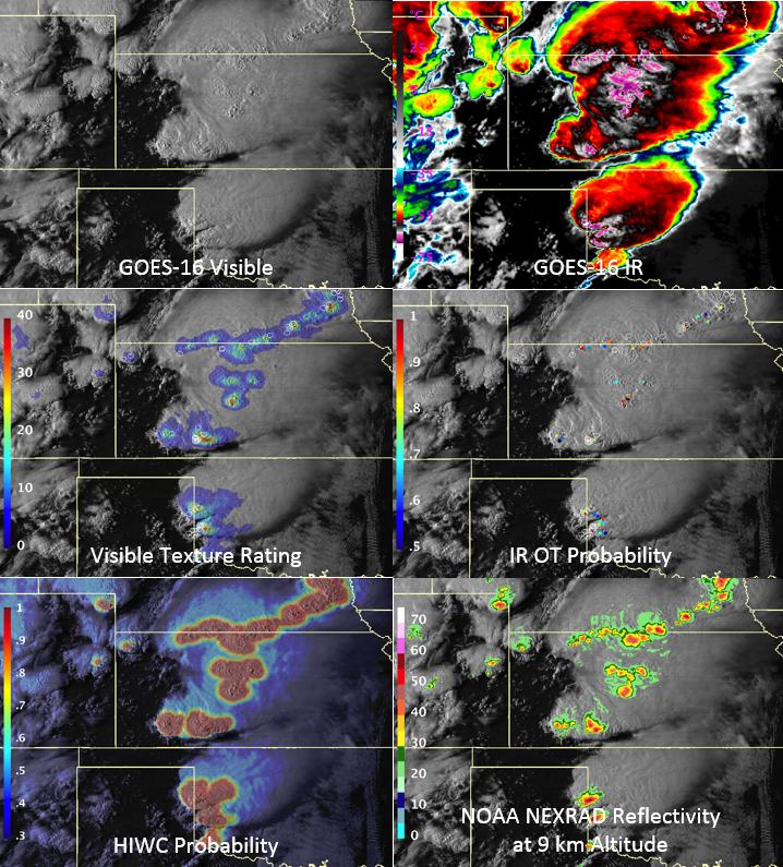
Overshooting Cloud Top Detection
Products developed and produced at the NASA Langley Research Center
Application:
Detection of hazardous convective updraft regions penetrating through (“overshooting”) the local anvil cloud using spatial patterns within visible reflectance and IR window temperature observations.
Storms with overshooting tops (OT) typically generate hazardous weather conditions such as hail, damaging wind, tornadoes, and flooding. They also are threats to aviation due to turbulence and aircraft icing conditions
The NASA Langley OT detection product suite provides:
1) Quantification of texture in visible imagery,
2) IR+NWP OT Probability,
3) Anvil cloud detection
4) Probability of High Ice Water Content (HIWC) indicating where aircraft engine and air probe icing conditions are likely within convection
Products can be produced using any LEO or GEO imager data and are available in NetCDF format upon request
Limitations:
Visible imagery unavailable at night, resulting in reduced OT detection and HIWC probability product accuracies.
Pros and cons:
✓ Applicable to any global imager on Polar or Geostationary satellite.
✓ Very efficient, can be generated over a broad geographic domain in < 5 mins. Useful for generating products for both weather forecasting and long-term climate data records.
✓ Good agreement with total lightning and tropopause level precipitation echoes, especially for the visible texture detection product.
✓ OT climatologies have been demonstrated in several peer-reviewed studies (see Additional Information), enabling assessments of climatological severe storm risk and regional/temporal storm distributions.
✓ OTs detected near ~60% of wind, hail, and tornadic storms.
✓ The first product of its kind for discriminating likely aircraft engine icing conditions at the storm cell scale.
X It is impossible to identify only the OT updraft areas and none of the nearby cold outflow using IR imagery alone.
X The ice water content distribution in a cloud is altitude dependent, with maximum values typically observed at lower altitudes. The HIWC probability product represents the likelihood in a vertical column based on spatial patterns and cloud properties depicted at cloud top, and therefore cannot be used to resolve icing conditions at a particular flight level.
Accessibility and Dissemination
- Products are available in AWIPS-II NetCDF format and are being provided with 5 min GOES-16 imagery for evaluation in an operational environment at NOAA National Centers such as the Aviation Weather Center, Weather Prediction Center, Ocean Prediction Center, and also at National Weather Service, Southern Region Central Weather Service Units (CWSUs)
- Products successfully demonstrated during the NASA High Ice Water Content – Radar 2 field campaign from 2-20 August 2018 over the Gulf of Mexico and Eastern Pacific Ocean
- Graphics over a US domain to be available at: https://clouds.larc.nasa.gov/cgi-bin/site/showdoc?docid=22&lkdomain=Y&domain=otdetection
Additional Information:
Bedka, K. M., C. Wang, R. Rogers, L. D. Carey, W. Feltz, and J. Kanak, 2015: Examining deep convective cloud evolution using total lightning, WSR-88D, and GOES-14 super rapid scan datasets. Wea. Forecasting, 30, 571–590, doi:10.1175/WAF-D-14-00062.1.
Bedka, K. M., and K. Khlopenkov, 2016: A probabilistic multispectral pattern recognition method for detection of overshooting cloud tops using passive satellite imager observations. J. Appl. Meteor. And Climatol. 55, 1983–2005, doi: 10.1175/JAMC-D-15-0249.1
Bedka, K. M., J. T. Allen, H-J. Punge, M. Kunz, and D. Simanovic, 2017: A long-term overshooting convective cloud top detection database over Australia derived from MTSAT Japanese Advanced Meteorological Imager observations. In review in J. Appl. Meteor. and Climatol.
Bravin, M., Strapp, J. W., and Mason, J., 2015: An investigation into location and convective lifecycle trends in an ice crystal icing engine database, Tech. rep., SAE Technical Paper 2015- 01-2130, SAE International, Warrendale, Pennsylvania, USA, doi:10.4271/2015-01-2130.
Punge, H-J, K. M. Bedka, M .Kunz, A. Reinbold, 2017: Hail frequency estimation across Europe based on a combination of overshooting top detections and the ERA-INTERIM reanalysis. Atmos. Res. In press, doi: 10.1016/j.atmosres.2017.07.025
Thiery, W, L. Gudmundsson, K. M. Bedka, F. H. Semazzi, S. Lhermitte, P. Willems, N. van Lipzig, S. Seneviratne, 2017: Early warnings of hazardous thunderstorms over Lake Victoria. Environ. Res. Lett., doi: 10.1088/1748-9326/aa7521
Yost, C. R., K. M. Bedka, P. Minnis, L. Nguyen, J. W. Strapp, R. Palikonda, K. Khlopenkov, D. Spangenberg, W. L. Smith Jr., A. Protat and J. Delanoe, 2017: A prototype method for diagnosing high ice water content probability using satellite imager data. In review in Atmospheric Measurement Techniques. Available online at: https://www.atmos-meas-tech-discuss.net/amt-2017-367/
Overview prepared by Kristopher Bedka, NASA Langley Research Center
< NEFODINA – Home – MSG “Sandwich” Image Product >