
Jan Kanak – SHMU (Slovakia)
IR Cold Cloud Tops product was already recommended during the workshop by Martin Setvak as being useful during summer convection season for the meteorologists and also for case studies of convective events. This product is generated from calibrated radiative temperatures of Meteosat 9 IR10.8 using the color scheme from blue to turqois to yellow and red applied over the fixed interval 200 to 240 K.
Another speciality of the processing approach is the weighted average of MSG pixels during reprojection from satellite view into conical projection. Weighting function depends on satellite zenith angle. This procedure makes better picture quality even in areas of very high satellite zenith angle.
This can be demonstrated with the results of smoothed reprojection in the pictures below. The first image is processed by using classical reprojection, where for each target pixel the address of source pixel is computed using projection function.
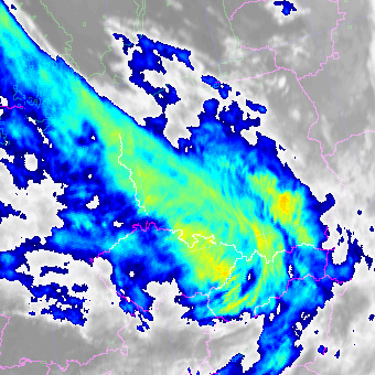
Fig. 1. Unsmoothed Meteosat enhanced IR10.8 satellite image.

Fig. 2. Smoothed Meteosat enhanced IR10.8 satellite image.
The second picture shows the result of the algorithm of Jan Kanak. The algorithm then finds 10 nearest source pixels for one target pixel. According to satellite zenith angle the number of source pixels which are uses into weighted average are set:
- When satellite zenith angle is small, number of source pixels is 1
- When satellite zenith angle is high, number is 10.
The last operation is the weighting of source pixels according to their distance to target pixel. The nearest one must have the maximum weight. The idea of Jan Kanak is to smooth source pixels before reprojection, not smoothing of target image after reprojection. The effect of this approach is not only for areas with very high zenith angle but alse in cases when zoom of reprojected target image is positive in comparison to source image. The method can be considered something like upscaling method. Addresses for set of 10 nearest pixels for each target pixel must be pre-computed due to huge number of arithmetic operations. It takes about 100 minutes on usual computer, but reprojection itself takes some few seconds, therefore it can be used operationaly, but of course only for geostationary satellites.